Thursday, June 22, 2017

What Cyclists Wish Drivers Knew 3: I’m Not a Road Hog

It doesn’t happen every time I ride a city street, but it happens often enough to remember: someone in a car passes close enough for me to feel the exhaust on my calf as it goes by. I recently had one driver tell me I was “riding at least three feet from the gutter” as he whizzeded by me at about 45 MPH (cell phone clamped to his ear, by the way). So let’s get something straight:

     State law in Indiana (and every other state I know of) says that cyclists must ride “as close as practicable” to the edge of the road. The word is practicable, not possible - -and it means “capable of being used.” In other words, if the right-hand three feet of the roadway aren’t safe to use, a cyclist may ride four feet from the curb. And, in fact, safety experts routinely suggest that cyclists “take the lane; that is, ride far enough from the curb that a car cannot pass them without crossing into the next lane. This, they say, makes a cyclist more visible and prevents timid drivers from trying to squeeze between a bicycle and the lane marker.

Friday, June 16, 2017

The Indy Cyclist’s Guide: Fall Creek Trail

If the Monon Rails to Trails project is the centerpiece of the Indianapolis cycling universe, the Fall Creek Trail is its redheaded stepsister. This trail – for the most part – sees far less traffic than the Monon; probably because the latter connects two of the Circle City’s most popular hipster havens, Broad Ripple and Mass Ave. That may also be why the Fall Creek trail is often – to be polite – less well-maintained.

Fall Creek Greenway Indianapolis
The trail has an “official” length of just over 13 miles (20.9 km), beginning at… well, no one knows quite where it begins, since it’s supposed to connect to the White River Greenway near 10th Street (but doesn’t). An official map shows the trail beginning at the intersection with the Monon half a mile or so south of 38th Street, though the physical trail continues south along Fall Creek until interrupted by construction near Central Avenue. On the northeast, the map shows it ending at mile 11 (actually mile 12) near Skiles Test Park, but in reality it extends to the Boy Scout Road bridge over the creek and a back entrance to Fort Harrison State Park. I’ll be talking about the section between the Monon and Fort Harrison.

Monon Trail to Binford Boulevard


The Monon Trail crosses Fall Creek and the trail on an elevated bridge. An access ramp connecting the trails can be found on the east side of the Monon near the north end of the bridge. Warning: watch for bicycles coming up the ramp! Down on the Fall Creek trail, there’s a small rest area equipped with benches. A cement post a few yards upstream marks this as Mile 6.0 on the Fall Creek Trail. From there, a paved asphalt trail extends in both directions…

…for a while: a little under half a mile up the trail, riders come to 38th Street – near northern Indy’s busiest east-west artery. The trail continues – if you can call it that – east on the sidewalk of the 38th Street bridge over Fall Creek. The broken, poorly-patched concrete sidewalk is studded with utility poles and barely wide enough for two pedestrians to pass. In short, it’s extremely dangerous – parents thinking this would be a good place for a child with training wheels will be shocked to find this on a “hike and bike trail.” Riders turn north to cross 38th at an intersection without a signal before the paved trail picks up on the other side.

The trail briefly follows Millersville Road and the (mostly abandoned) Nickel Plate rails before diving under Keystone Avenue and winding through a small, surprisingly woody area. After crossing the creek on a pedestrian bridge parallel to Binford Boulevard, the trail reaches a parking area just east of the intersection of Binford and Fall Creek Parkway North, at approximately mile 7.5 of the trail. A side trail at 39th Street gives trail users access to the east entrance of the Fairgrounds via a historic limestone bridge and a signal-controlled crossing of Binford.

Binford Boulevard to Skiles Test Park


The 2.25 miles between the parking area and the six-way intersection of Fall Creek Parkway, Emerson, and 56th Street runs between parkway and creek. It passes under 46th, Emerson, and 56th before turning east to follow the Parkway from its intersection with Kessler Boulevard at about mile 10. Watch for a steep, slick climb northbound on a wet wooden bridge under 56th street, and beware of heavy growth of poison ivy in the adjacent underbrush. The pavement in this section is often narrow and rough, with many ridges caused by tree roots. It’s also subject to flooding and mud when the weather has been rainy. Road cyclists generally ride on the Parkway, which alternates between smooth, fresh pavement and broken, potholed asphalt.

From Kessler and Fall Creek the trail again runs between the parkway and the creek. This section is wide and smoothly paved, unlike the portion of the trail west of Emerson, with a better surface than the street it parallels. It's curvy and and has lots of little rolling hills. Pullouts along the Parkway about every half mile act as parking areas for the trail, with an official trailhead near mile 12.25 where there's a side trail into Skiles Test Park. Four tenths of a mile up that trail lies another parking area, and the trail continues up a steep (for Indy) hill 0.75 miles to meet 65th street east of Johnson Road.
    

Skiles Test Park to Boy Scout Road


The Fall Creek Trail continues, passing underneath I-465 – watch for mud beneath the southbound lanes, which never seems to be cleaned – then alongside Fall Creek Road for 0.8 miles to the current end of the trail at Boy Scout Road. The trail crosses the intersection to the sidewalk on the north side of the bridge, at the end of which a trail continues into Fort Harrison State Park. The intersection's crosswalk is clearly marked, but still unacceptably dangerous because of heavy, high-speed traffic and the need to make a sharp right-hand turn from the pavement to the narrow sidewalk. Many cyclists prefer to ride in the traffic lanes instead of attempting the crossing.

The Bottom Line


There are no amenities along the trail beyond an occasional bench at a trailhead. There are no water fountains and no public restrooms anywhere in its length. Water and restrooms are available within Fort Harrison State Park, and there are businesses at the Fall Creek / Emerson / 56th Street intersection – including a Starbucks, a CVS, and Lincoln Square Pancake House.

     Unlike the Monon, the Fall Creek Trail is usually lightly traveled. On weekdays, riders may encounter only a handful of pedestrians and cyclists on their trip. Perhaps because there’s less traffic, the trail is not as well-maintained as the Monon, overhanging branches and underbrush are common (be wary of poison ivy in the mix!) and obstructions like mud and fallen trees aren’t removed with such speed. On the other hand, you almost never run into three people walking abreast pushing strollers...
copyright © 2017-2020 scmrak

Wednesday, June 7, 2017

Why Is Buying a New Computer Such a Hassle?

I don't know about you, but I like having a computer on my bike: I want to know how fast I'm going, how far I've gone, and the fastest I've gone today (for the record, I hit over 42 MPH on a bike outside Austin once). In other words, when my computer goes wonky I replace it...

A few rides ago the CatEye Strada I'd been using started acting up. At first, I was just getting slightly shorter distances than the Ms on the same ride, but pretty soon it was serious. I replaced batteries in both the sensor and the computer, but to no avail (the Strada was, of course, six or eight months out of warranty). So I sucked it up and bought a new on. I went to my local REI and picked up a CatEye Micro Wireless
Sadly, that was a mistake. CatEyes are always a pain in the tuchus to set up, in part due to those horrid instruction sheets, but this one seemed even worse than usual. After I did get it set up, I just clipped it into the mount for the Strada, left the sensor in place, and took off on a 25-mile spin. According to the Ms's computer, it was 25 miles -- according to the new Micro Wireless, it was a little under 21 (yes, the tire size was correctly set: 2105mm for a 700x25C). That's not to mention that the speedometer read 0.0 for all but a few hundred yards, the average speed was 11.1 MPH, and my alleged maximum speed was 4.6 MPH (a mathematical impossibility with that average). I changed the battery in the computer and installed a new sensor -- on the other fork -- but it didn't make any difference.

Kudos to REI: they gave me a full refund.

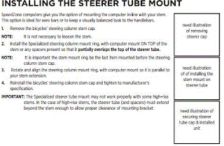
instructions for Specialized SpeedZone stem mount
So I tried a different tack: A Specialized SpeedZone Sport Wireless that I bought at my LBS. Problems abounded when I opened it: for one, the battery in the computer was dead (it takes years for a CR2032 to go dead without a load). For another, there were no instructions for using the stem mount doodad they'd included -- heck, they didn't even list it in the parts. There was a note on the instruction book, though, telling me to go to www.specialized.com and click on the "support" tab. Surprise, surprise: there is no "support" tab -- there hasn't been one in about five years! So I sent an email to what they call Rider Care asking what size stem the doodad fits... in answer to my question "are there instructions anywhere?" got this back:
specialized speedzone sport wireless
"I have included the link to the stem mount for the SpeedZone computers. This is mounted under the top cap. It is a pretty easy installation, you simply need to remove the bolt and top cap, put this mount on top of any spacers you have, and reinstall the top cap and bolt."
Of course, it took 50 hours or so to get even that response... by which time I'd already returned the damned thing (kudos to Matthews Bicycles -- returned, no questions asked). Interestingly enough, in the interim I found a PDF of the instructions, which you can see to the left. Note the "helpful" pictures... NOT.  That's not to mention that I don't have the specs for torque on the stem cap bolt and don't have a torque wrench, either.

Finally, I gave up and went back to REI and replaced the Strada with another one. So far, it seems to work just fine -- and CatEye appears to have gotten the message about their crappy instructions, at least to some point. By the by, jeers to the local Performance store: I was in there Friday, Saturday, Sunday, and Tuesday -- and the rack of computers was more or less empty every day. They really ought to be ashamed...

But will someone tell me why it is so hard to find a non-GPS enabled bicycle computer? Frankly, I don't need a GPS to tell me where I am, and I'm pretty sure that the vast majority of cyclists don't need a $300 device to tell them how fast they're going. At the other end of the spectrum, I don't know about you but I'm not gonna buy a nineteen-dollar "wireless" bike computer from some weird Chinese company...
copyright © 2017 scmrak