Showing posts with label cycling. Show all posts

Saturday, July 1, 2023

I'm Not a Lawyer, but...

Update: as of August 1, 2023, the pipe and bridge have been removed.

 
Fall Creek Greenway "ramp"

...I'm going to suggest that this ramp isn't ADA-compliant.

I encountered these workers installing the ramp over an 18-inch pipe laid across the Fall Creek Greenway on June 28th. The work was going on about a quarter mile north/east of 39th Street (that's the parking lot of Pro-Strip, 4020 Millersville, in the background). I'll grant that, unlike the makeshift plywood ramps cobbled together by DigIndy contractors across the trail at sites near Central and Illinois Streets in recent years, the ramp is actually... semi-safe. It's constructed of metal mesh with handrails and doesn't have overly steep approaches.

Sunday, June 25, 2023

Trail Updates and Down-Lows

Jersey Barrier
You Shall Go No Further!
There’ve been interesting developments on the local multiuse trails of late, so here’s the latest that I know about. First, the Monon Rail Trail detour around the North Split construction is no more: traffic has resumed following the original pathway beneath I-65 to 10th Street, where you can connect with the easternmost leg of the Cultural Trail. In theory, you can connect with the Pogue’s Run trail too, though when I last went through, the sidewalk was mostly blocked by construction signs between the Monon and Dorman Street. The loop that runs alongside College is closed, though you can go west from the main trail.

Monday, January 9, 2023

Indy’s Most Dangerous Bike Trail Intersections: Number Three

After the death of a well-known local cyclist (October, 2021) where the Monon Trail crosses 86th Street, many within the cycling community called for changes to make improve the city's cycling safety. We've noticed that there's been a change, but not much of one: traffic engineers reprogrammed the pedestrian crossing lights at the intersection where he was killed to give trail users a 10-second window when no motor vehicles have a green light. Now, if engineers could just reprogram those drivers who routinely ignore the “no turn on red” signs…

Although it's certainly a dangerous crossing, in our opinion the intersection where he was killed is not the most dangerous in Indy for cyclists, not even the most dangerous intersection of a trail and a street. So without further ado, here is our next nomination within the bottom six street crossings in Marion County, number three…

Indy’s Most Dangerous Bike Trail Intersections: Number One

When a well-known local cycliest was struck and killed near the Monon Trail (October, 2021), members of the Indy bicycle community called upon the city to make changes that might make cycling in the city safer. To our uncertain knowledge, there has in fact been such a change. By “such a change,” we mean just the one: traffic engineers reprogrammed the pedestrian crossing lights at the Monon trail / 86th Street intersection where Frank Radaker was killed; allowing trail users a 10-second window when no motor vehicles have a green light. Now, if engineers could just reprogram those drivers who routinely ignore the “no turn on red” signs…

Although decidedly dangerous, in our opinion the intersection where Frank perished is not the most dangerous bike crossing in Indy, not even the most dangerous intersection of a trail and a street. Without further ado, here is our nomination for the most dangerous bike trail / street crossing in Marion County…

Monday, May 25, 2020

Good News, Bad News on Westfield Bridge

Updated

Some time around Memorial Day, Westfield opened the bridge to traffic. Two things to know:
  • There's a road (access to restaurants?) that crosses the south approach. I'll just say that it's "inconvenient" amd leave it at that. Southbound riders be aware.
  • The surface is not particularly smooth.

Artist's conception, Westfield's Monon bridge

Friday, October 19, 2018

Hamilton County Opens New Section of Monon

What's arguably Indy's favorite multipurpose trail can now take cyclists (and hardy runners) almost all the way across Hamilton County as well as between Mass Ave and SoBro. On Wednesday,  county officials cut the ribbon on a newly-paved section some three miles long, giving users access to an off-street trail that now reaches all the way to the outskirts of Sheridan, nearly at the Hamilton-Boone County line.

Wednesday, October 4, 2017

Things Cyclists Wish Drivers Knew #5: That White Line Is Not a Force Field

fog line on paved road
For a lot of the past couple of decades I lived in different cities in Texas – a state that's quite possibly the very model of modern bicycle hostility (though I must admit I’ve never ridden in Mississippi, Florida, or Alabama). Then-gov Rick Perry – who at the time claimed to be a cyclist – once vetoed a safe-passage law passed by the scarlet-red legislature, effectively making anyone with a driver’s license a double-oh agent. Kidding. Sort of. But now I live in Indiana... and not much has changed.

The Hoosier State, like Texas and nine other states (AK, HI, ID, ND, NM, IA, MI, KY, NJ)¹, has no legal mandate for a minimum passing distance when a motor vehicle overtakes a slow-moving vehicle such as a bicycle or Amish buggy. Some cities (Carmel, for instance) have passed local ordinances, but out on country roads it can be “Katy, bar the door!”
When riding city streets, especially those with striped bike lanes, and roadways with a fog line along the side of the road, most cyclists do try to stay to the right of the line – even though they are not required by law to do so. It’s common courtesy… What isn’t common courtesy, however, is the motorists who whiz by in the closest traffic lane without paying any attention to the cyclist, as if the white line at the edge of their lane marked a Star Trek-style force field.

Just so you know, there is no such thing!

A bicycle or pedestrian on the side of the road is just as fragile as one in the middle of the road. Show some common courtesy, people, and leave them enough room to maneuver around road hazards.

¹ The differing state laws are detailed by the National Conference of State Legislatures 
    
copyright © 2017-2018 scmrak

Tuesday, July 25, 2017

What Cyclists Wish Drivers Knew 4: We Can’t Always Ride on that Bike Path!

Talk about your bridge to nowhere...
If often seems to me that there are only two kinds of people in this world, or at least on the internet: there are the people who ride bicycles on the streets and there are the people who detest them. Sorry, that’s kind of a generalization… but when it comes to being vocal about cyclists and cycling on the streets, the dichotomy certainly seems to fit. All you need do is look at the comment section on any story about bicycles or cyclists, and you’ll see plenty of venting from the second group. Take, for instance, a recent post in the “Let It Out” section of the Indianapolis Star, in which the anonymous writer asked, “Why is this guy riding his bicycle in the street when our taxes paid for that nice new bike path?”

You see the word “taxes” come up a lot in discussions of bicycles on streets, since so many non-cyclists are of the (mistaken) impression that gasoline taxes and vehicle registrations pay to maintain local streets: they don’t – local property taxes pay the bulk of that cost. But that’s not my point today – my point is the question, “Why aren’t you using the bike path my money built for you, Lycra-clad loser?” The answer’s pretty simple, especially in towns that – like Indianapolis – are at best only moderately bicycle-friendly: The bike paths don’t go where I need to go; the streets do.

      There’s more, of course. When people drive cars – and most adult cyclists also drive – they generally take the most efficient route. That means avoiding heavy, slow-moving traffic and streets that are in such poor repair that they slow them down. They use I-74 instead of Crawfordsville Road to get from Brownsburg to Indy, for instance. Well, on a bicycle, it’s the same: it’s inefficient to try to ride the Monon Trail when it’s filled with strollers, and it’s nearly impossible to ride the Fall Creek Trail when (and after) the creek has flooded it. I’ve seen bike trails blocked by standing water, fallen trees, official trucks (lots of times), landscaping crews’ trucks, and bridge construction; to name a few reasons I found myself riding in the street.

That’s assuming, of course, that there’s a trail – and that it’s continuous. Out in Hamilton County, many a trail has been built up to the limits of the subdivision, where it then simply ends. We’ve even seen bridges to nowhere on some of our rides (see photo above). Alleged bike paths that just stop in the middle of a block dump riders out onto the streets, sometimes at seriously bad locations. Oh, and for what it’s worth? Many of those bike paths are part of the subdivision’s green space, and weren’t built with taxpayer funds…

So gimme a break, please, drivers! The reason I’m in the street instead of on the bike path is  the same reason you’re on that street: it goes where I’m trying to go!

copyright © 2017 scmrak

Friday, June 16, 2017

The Indy Cyclist’s Guide: Fall Creek Trail

If the Monon Rails to Trails project is the centerpiece of the Indianapolis cycling universe, the Fall Creek Trail is its redheaded stepsister. This trail – for the most part – sees far less traffic than the Monon; probably because the latter connects two of the Circle City’s most popular hipster havens, Broad Ripple and Mass Ave. That may also be why the Fall Creek trail is often – to be polite – less well-maintained.

Fall Creek Greenway Indianapolis
The trail has an “official” length of just over 13 miles (20.9 km), beginning at… well, no one knows quite where it begins, since it’s supposed to connect to the White River Greenway near 10th Street (but doesn’t). An official map shows the trail beginning at the intersection with the Monon half a mile or so south of 38th Street, though the physical trail continues south along Fall Creek until interrupted by construction near Central Avenue. On the northeast, the map shows it ending at mile 11 (actually mile 12) near Skiles Test Park, but in reality it extends to the Boy Scout Road bridge over the creek and a back entrance to Fort Harrison State Park. I’ll be talking about the section between the Monon and Fort Harrison.

Monon Trail to Binford Boulevard


The Monon Trail crosses Fall Creek and the trail on an elevated bridge. An access ramp connecting the trails can be found on the east side of the Monon near the north end of the bridge. Warning: watch for bicycles coming up the ramp! Down on the Fall Creek trail, there’s a small rest area equipped with benches. A cement post a few yards upstream marks this as Mile 6.0 on the Fall Creek Trail. From there, a paved asphalt trail extends in both directions…

…for a while: a little under half a mile up the trail, riders come to 38th Street – near northern Indy’s busiest east-west artery. The trail continues – if you can call it that – east on the sidewalk of the 38th Street bridge over Fall Creek. The broken, poorly-patched concrete sidewalk is studded with utility poles and barely wide enough for two pedestrians to pass. In short, it’s extremely dangerous – parents thinking this would be a good place for a child with training wheels will be shocked to find this on a “hike and bike trail.” Riders turn north to cross 38th at an intersection without a signal before the paved trail picks up on the other side.

The trail briefly follows Millersville Road and the (mostly abandoned) Nickel Plate rails before diving under Keystone Avenue and winding through a small, surprisingly woody area. After crossing the creek on a pedestrian bridge parallel to Binford Boulevard, the trail reaches a parking area just east of the intersection of Binford and Fall Creek Parkway North, at approximately mile 7.5 of the trail. A side trail at 39th Street gives trail users access to the east entrance of the Fairgrounds via a historic limestone bridge and a signal-controlled crossing of Binford.

Binford Boulevard to Skiles Test Park


The 2.25 miles between the parking area and the six-way intersection of Fall Creek Parkway, Emerson, and 56th Street runs between parkway and creek. It passes under 46th, Emerson, and 56th before turning east to follow the Parkway from its intersection with Kessler Boulevard at about mile 10. Watch for a steep, slick climb northbound on a wet wooden bridge under 56th street, and beware of heavy growth of poison ivy in the adjacent underbrush. The pavement in this section is often narrow and rough, with many ridges caused by tree roots. It’s also subject to flooding and mud when the weather has been rainy. Road cyclists generally ride on the Parkway, which alternates between smooth, fresh pavement and broken, potholed asphalt.

From Kessler and Fall Creek the trail again runs between the parkway and the creek. This section is wide and smoothly paved, unlike the portion of the trail west of Emerson, with a better surface than the street it parallels. It's curvy and and has lots of little rolling hills. Pullouts along the Parkway about every half mile act as parking areas for the trail, with an official trailhead near mile 12.25 where there's a side trail into Skiles Test Park. Four tenths of a mile up that trail lies another parking area, and the trail continues up a steep (for Indy) hill 0.75 miles to meet 65th street east of Johnson Road.
    

Skiles Test Park to Boy Scout Road


The Fall Creek Trail continues, passing underneath I-465 – watch for mud beneath the southbound lanes, which never seems to be cleaned – then alongside Fall Creek Road for 0.8 miles to the current end of the trail at Boy Scout Road. The trail crosses the intersection to the sidewalk on the north side of the bridge, at the end of which a trail continues into Fort Harrison State Park. The intersection's crosswalk is clearly marked, but still unacceptably dangerous because of heavy, high-speed traffic and the need to make a sharp right-hand turn from the pavement to the narrow sidewalk. Many cyclists prefer to ride in the traffic lanes instead of attempting the crossing.

The Bottom Line


There are no amenities along the trail beyond an occasional bench at a trailhead. There are no water fountains and no public restrooms anywhere in its length. Water and restrooms are available within Fort Harrison State Park, and there are businesses at the Fall Creek / Emerson / 56th Street intersection – including a Starbucks, a CVS, and Lincoln Square Pancake House.

     Unlike the Monon, the Fall Creek Trail is usually lightly traveled. On weekdays, riders may encounter only a handful of pedestrians and cyclists on their trip. Perhaps because there’s less traffic, the trail is not as well-maintained as the Monon, overhanging branches and underbrush are common (be wary of poison ivy in the mix!) and obstructions like mud and fallen trees aren’t removed with such speed. On the other hand, you almost never run into three people walking abreast pushing strollers...
copyright © 2017-2020 scmrak

Thursday, May 11, 2017

The Amateur Bike Mechanic's Workbench

Park Tool PCS-10


Park Tool PCS-10 Work stand with carbon-frame bicycle held by seat post
Bicycles aren't really particularly finicky machines. Well-constructed rides can survive benign neglect for quite a while before “demanding” a tune-up, especially if they're rarely used. You’re wise to keep up your lubrication, but you might not notice problems if you don’t ride much. If you ride more than a few times a summer, though, you’re aware that regular maintenance and cleaning are absolute musts. You need a stand for those chores; one like the Park Tools PCS-10 Home Repair Stand.

The PCS-10 is considered a portable stand because it folds for storage and transport. It suspends mountain, hybrid, cyclocross, gravel, tri, or road bikes (cruisers and recumbents, too) from a top-mounted clamp that grasps tubes ranging from 7/8 to 3 inches in diameter. Lift height ranges from 39 to 57 inches, high enough to position most bikes for easy access to any component. A cam-operated, padded clamp locks the bike in place while the three-point leg system keeps everything stable. Loosen a pair of quick-release clamps, fold the legs, and the PCS-10 collapses to a compact 41” tall, small enough to lean in a corner. The quick-releases are the stand’s chief difference with the less-expensive PCS-9.

     The clamp is the heart of the PCS-10. Padded jaws, three inches wide, grasp any tubing gently – seat, top, down, head; or the seat post for a carbon frame. It closes with a slick cam arrangement to avoid over-tightening; and the whole mechanism rotates through a full 360° to lock the bike at any angle.

The PCS-10 comes disassembled in a large, 25-pound box with the tools needed for assembly. The included instructions are, sadly, a little tough to follow. They are, however, printed in four languages… Assembly takes fifteen to twenty minutes, much of which is spent flipping the paper back and forth between text and illustrations.

When assembled, the PCS-10 is an engineering marvel. It’s sturdy – its three-point stance makes it nearly impossible to tip over – and versatile. You can mount the bike in any position, rotate it while clamped in place, and raise and lower the stand easily. The footprint is large when opened (for stability), but once folded the stand is about the size of a smallish golf bag.     

Park accessories for the PCS-10 include a couple of work trays for tools (got one), a paper-towel holder (got it), a wheel truing attachment (need one), and a nylon carry bag. Fun fact: Park has trademarked this color of BLUE (their caps).
copyright © 2017 scmrak

Tuesday, May 2, 2017

Indy's Monon Trail: Love It? or Hate It...

Monon Trail Sign Carmel Indiana
If you live anywhere near Indianapolis you know about the city's Monon Trail, even if you haven’t ridden a bicycle in thirty years – maybe even fifty years. It’s that rails-to-trails project that follows the abandoned Monon Railroad tracks from just east of where Mass Ave meets 10th Street downtown to a current terminus in northern Hamilton County. As of this writing, it’s officially 19-plus miles long, ending near IN 32 and US 31 in Westfield. A bit more than ten miles of the Monon are in Marion County, where the trail is generally considered the jewel of Indy’s bike paths. Some local cyclists, however, say it's a rhinestone at best.


Here are some reasons to avoid the Monon


Safety: Between the south end and where the trail crosses White River north of Broad Ripple, there are at least twenty at-grade street crossings, ranging from sleepy 17th Street to six lanes of fast-moving traffic at 38th Street. That includes a bizarre three-corner crossing of Westfield and Riviera in downtown Broad Ripple. Cyclists and pedestrians are routinely struck or just missed in many of the crossings, which are marked simply by signs saying “Pedestrian Crossing” and “Monon Trail,” plus the occasional blinking yellow light. Only Kessler Boulevard and Fairfield Avenue rate bridge crossings, which use former Monon railroad bridges. Besides the ever-present danger of car-bike accidents (there are already ghost bikes at 20th and 75th), stopping for a street every two blocks plays hell with your average speed…

      There's an equally frustrating set of street crossings in downtown Carmel, with three street crossings in 1/8 mile including very heavy Main Street traffic.

Amenities: Although water and bathrooms are more common in Hamilton County (starting with a  nicely-appointed rest station where the trail crosses 96th Street), trail users coming from downtown will not find water along the trail until the entrance to the Deaf School at 42nd Street (3.6 miles) and won’t find a public restroom until Canterbury Park at 56th Street (5.2 miles). A few bike repair stations are scattered along the trail (e.g., at 52nd Street and the Fall Creek bridge), but the tools and pump have often been stripped or destroyed. Emergency telephone stations can be found at regular intervals south of 38th Street.

Hanging a little over the center line, Blondie?
Traffic: It goes without saying that any cyclist hoping to make good time should avoid the trail on weekends and around lunchtime. Through SoBro and Broad Ripple the trail is crowded with pedestrians, some of whom walk in groups of four or five abreast. Children and, to a lesser extent, dogs often dart into the path of unwary cyclists. You need to be especially wary around venues like Broad Ripple Ice Cream Station, where BRICS patrons have been seen wandering blindly around the path nursing their ice cream headaches.

Some people absolutely love the trail


Long open stretches can be found, if that’s your bag. Take, for instance, the wooded trail adjoining Marott Park and the Blind School north of Broad Ripple, with only a stoplight-controlled crossing at 75th Street to break up the 2¾ miles between 65th and 86th Streets. Up in Carmel, busy street crossings are made safer by bridges (Carmel and City Center Drives) or underpasses (116th, Meridian, and 146th). There's also park access along or near the trail for much of its length (Canterbury, Broad Ripple, and Quaker Parks).

      Ice cream riders really have no excuse not to stop at BRICS, and restaurants can be found at almost every street crossing between 52nd and White River, with dozens easily accessible in the Broad Ripple area – though there are far fewer in the industrial sector between 10th and 38th. Speaking of industrial areas; if you like the smell of heated wood, Wooley Lumber’s kilns at 30th Street will warm the cockles of your heart.

Local art abounds in the murals on trail-side buildings between 52nd and 54th, as well as lots of unusual backyard art in trail-side homes. Jordan YMCA users enjoy an easy-access entrance to the trail at about 82nd Street.

The bottom line


Overall, the trail is well cared-for – better than the city’s streets a lot of the time. It’s so well cared-for that other trails in the city suffer greatly by comparison: ride the Fall Creek Trail some time and you’ll probably find fallen limbs and low-hanging vines, even in the sections that are passable (which rules out much of the section between 56th and Keystone). After the same storm, the Monon is quickly swept of fallen twigs and leaves like a street in Singapore.

One thing that bothers me as both a cyclist and a driver… after a “young girl” was struck by a car at the 111th Street-Monon crossing, the Indianapolis Star said,
pedestrian crossing stop sign
“The intersection is marked as a crosswalk with yellow flashing lights with a pedestrian-crossing sign. Once pedestrians or bicyclists stop, determine it's safe to cross and proceed into the crosswalk, they have the right of way under state law. Traffic must yield to pedestrians in crosswalks by slowing down or stopping.”
From long experience, I’m aware that many drivers are unaware of that section of the traffic code; and a frightening few are “aggressively” ignorant. Given the popularity of this trail and the dangers to its users from inattentive drivers, why Indianapolis refuses to use traffic signs such as the one shown at right at the Monon (and other at-grade crossings) remains a mystery to me.
copyright © 2017-2019 scmrak

Sunday, December 11, 2016

A Beginner's Guide to Houston's Terry Hershey Trail, Part 1

OK, so you're not one of the bony types who hang out in the break room at the office hitting up all their co-workers for a pledge to this year's 180-mile BP MS150 between Houston and Austin. You don't own a single item of Spandex®, and your bike weighs about the same as a set of the Encyclopedia Britannica. That doesn't mean you can't get out on your bike and enjoy the fresh air while you get some exercise. If you live or work near Houston's Energy Corridor, you have a great opportunity right at your doorstep: the Terry Hershey Trail.

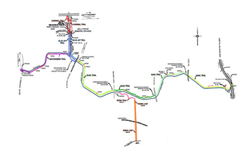
Managed by Harris County Precinct 3, the paved trail follows the banks of Buffalo Bayou from the foot of the Addicks Dam (at George Bush park) to a terminus at the Sam Houston Tollway (Texas 8), a distance of some 6.5 miles. In 2013, the county added an arm to the trail that provides access to the Addicks Park-n-Ride lot. The main trail is separated  into five more or less equal sections by major north-south streets: from the West, they are Eldridge parkway, Dairy Ashford Road, Kirkwood Road, and Wilcrest Drive.

Section 1 - Bush Park to Eldridge Parkway


The trail runs along the south side of Buffalo Bayou through a lightly wooded area. There are several bridge crossings at small drainages: watch for a "step" of up to an inch where the path meets the concrete pad (the precinct fills these occasionally, but they soon redevelop). At about one mile, a footbridge across the Bayou (see right) leads to the 500-acre Terry Hershey Park on Memorial Drive. That path loops back to meet the main Hershey Trail just west of Eldridge, about a one-mile loop. There are drinking fountains (human and dog) along the loop trail and even a shower to help cool down runners.

The west end of the so-called "anthill," used by fat-tire enthusiasts, parallels the paved trail off to the right (south) through this section. After a rain, be wary of heavy mud coating the trail in spots where the off-road trails veer to the side and uphill.

Parking is available north of the Bayou on the west side of Texas 6. To reach the trailhead, you must cross the Highway 6 bridge on a narrow, one-lane sidewalk. Parking is also available at the park on the north side of Memorial as well as along Memorial Mews south of Memorial. Restrooms, water, and picnic tables are available at the park; only picnic tables can be found at the western end and a water fountain near the zero mile marker.

Section 2 - Eldridge Parkway to Dairy Ashford Road


The trail runs along the north side of the Bayou from the east side of Eldridge to the other end. Eastbound cyclists can reconnect with the main trail by crossing the Bayou on the Eldridge bridge (only wide enough for one bicycle!) and turning left to loop under the roadway. A restroom with drinking fountains sits just east of Eldridge, and you can also connect with a bicycle route that follows Enclave Parkway. This section of the trail is also mostly flat, though there are a few slight inclines and several sharp turns.

Parking is available at Dairy Ashford on the south side of the Bayou; to reach the trail you must cross the bridge either on the road surface (not a good idea) or on an open sidewalk. At the west end, some folks park in the Kendall Library lot on the northwest corner of Eldridge and the Bayou (preferably when the library is closed). There are no restroom facilities in this section, nor is there water. Benches and picnic tables can be found all along the paved trail.
There is access to the Robin Trail, a 1.8-mile loop (mostly crushed granite) at the east end of the Dairy Ashford parking lot. The Robin Trail connects with a city bicycle lane on Briar Forest Drive, about half a mile south. If mud's your thing, you can connect with the dirt trails through the woods on the south side of the Bayou by dropping down the banks on the east side of the bridge.

Trail Etiquette


Cyclists must yield the right of way to everyone, even if they're hogging the trail. Watch for loose dogs (in defiance of park rules) and new moms weaving around with strollers while texting. Be safe: announce your presence to pedestrians and other cyclists before passing, and never stop and stand on the trail.     

Coming Next: The rest of the trail...

copyright © 2016-2017 scmrak

Monday, October 10, 2016

Rails to Trails from Muncie: Mile 80-100, Cardinal Greenway

Our first-ever Indiana Rails to Trails ride took us to the Cardinal Greenway, a planned 140-plus miles following abandoned Chessie System (Chesapeake and Ohio, now CSX) tracks. As of this writing, the trail reaches 65 miles from mile marker 62 in Richmond to 127 in Marion. We started in Muncie's Mansfield Park, just north of Mile Marker 100, and traveled south to 80.5, a tad short of the little village of Economy.